
The citadel
The citadel and defences of the Casbah of Algiers
The whole quarter is named after this building, and almost nobody gets inside it. Sixty years of restoration and counting.
Everyone uses the word casbah to mean the whole old town of Algiers. It did not start out that way. It named one building, the fortress at the top of the hill, and the rest of the quarter borrowed the name later. That building is still there, still the highest thing in the medina, and it has been under restoration for longer than most Algerians have been alive.
The word started here
Qasba means citadel. In the Zirid period, when the city that became Algiers was founded, the term applied only to the fortified summit of the medina and to nothing else. Today, as UNESCO uses it, the Casbah means the entire old town within the line of the ramparts.
So the name travelled downhill. When people say the Casbah now they mean the whole 54.7 hectares that UNESCO inscribed in 1992, a triangle of dense housing running from the summit at roughly a hundred and twenty metres above the sea down to the water. The fortress that once owned the word is now one building inside it.
1516 to 1592: the fortress and the wall
The Ottoman fortifications of Algiers were built between 1516 and 1592. That is a long build, and it covers the period in which Algiers went from a coastal town to the seat of a regency that mattered across the whole western Mediterranean. The walls went up as the city's ambitions did.
What the ramparts enclosed is exactly what is protected now. The area UNESCO inscribed is the area the wall once closed, which is why a boundary drawn by sixteenth-century military engineers is still doing administrative work in the twenty-first century.
The defences were not only about the landward approach. Algiers made its living from the sea and expected to be attacked from it, and the fortifications ran right down to the waterline. The bombardment of 1682 is the clearest reminder that the expectation was reasonable: it destroyed the mihrab of the Great Mosque, among much else.

Wall of the citadel. Built as military engineering, and now the line that defines a World Heritage boundary.
A palace that took four centuries
Inside the citadel is the palace of the dey, the seat of government of Algiers until 1830, and the most misunderstood building in the quarter. It is not one building from one date. Research on its structure describes it as built across the sixteenth to the nineteenth centuries, and the sequence has been worked out by stratigraphic study, reading the fabric itself in layers the way an archaeologist reads ground.
The complex covers about eleven thousand square metres, which makes it many times the size of any of the palaces down the hill. But the logic is the same one those houses follow. It is an accretion. Rooms were added, courts were closed in, levels were built over, and the result is a plan that records four hundred years of decisions rather than the intention of a single architect.
That is also why it is so hard to repair. You cannot restore a building to its original state when there is no single original state to restore it to. Every choice about the dey's palace is an argument about which century to prefer.
1830: the room where it ended
On 4 July 1830 the bombardment of Algiers began. On 5 July the city surrendered, and Dey Hussein went into exile. Three centuries of government from this hilltop stopped inside about thirty six hours.
What happened next to the citadel is a matter of record because the people who took it drew it. The survey plan of the citadel reproduced below dates from 1830 and was made by the incoming French administration, which is worth remembering when reading it: it is an accurate document produced for the purpose of holding the place.

The citadel surveyed in 1830. An accurate plan, drawn by the people who had just captured it.
Water, and the things that are easy to miss
A fortress on a dry hill has one problem before it has any others. Algiers had no river, and everything it drank arrived by aqueduct from the hills behind the city. One such aqueduct was built in 1610 to supply the hammams.
This is not a footnote to the defences, it is part of them. A city that can be cut off from its water cannot hold out, and the aqueducts and the hundred and twenty five public fountains recorded by 1674 are as much a part of the military picture as the walls are. There is more on the water elsewhere on this site.
Bastion 23, the other end of the system
The defensive line did not stop at the citadel. At the waterfront stood the complex now known as Bastion 23, the Palace of the Raïs, built in the sixteenth century under Ramdan and Mustafa Pasha and lived in by the ship captains and the men who worked the port.
It survived the demolition of the marine quarter after 1830, which almost nothing else did, and its restoration was launched in July 1988 across about four thousand square metres. It is covered properly on the dars and palaces page, because it is as much a group of houses as a fortification, which is precisely the point about this city: the same building did both jobs.
Sixty years of scaffolding
Restoration of the citadel began in the late nineteen sixties and is still under way. The dey's palace itself has been under a restoration that began in 2006, and it is still behind scaffolding.
Money has not obviously been the constraint. In 2016 the Algerian culture minister stated that six hundred and seventy five million euros had been spent on the Casbah over the years, with little to show for it on the ground. Conservation work is carried by the national conservation agency and by voluntary organisations, among them the Association Arts et Patrimoine d'Alger.
It would be easy to write that as simple failure and it is not quite that. Restoring a four-hundred-year accretion in a seismic zone, in a quarter where the streets are too narrow for machinery and the neighbouring buildings are propped up with timber, is genuinely one of the harder conservation problems anywhere. But sixty years is sixty years.
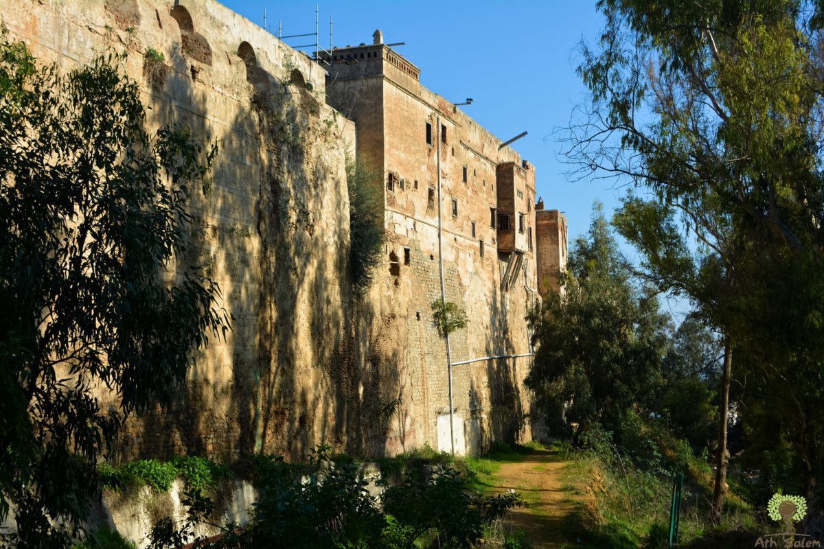
The upper defences. Scale is hard to read here, and that is part of why the citadel is so easily overlooked from below.
What is threatening it
UNESCO lists the standing threats to the site as earthquake, fire, landslide and flood. For the citadel specifically, a structural study of the dey's palace recorded damage from historical and recent earthquakes, from bombardment, and from later alterations made by people, and found that each of those increases the building's vulnerability to the next earthquake. Algiers is a high seismic risk city and the palace is a damaged building in it.
For the quarter around it, a recent count put one thousand eight hundred and sixteen buildings still standing, of which about forty per cent are critically damaged or already ruined and roughly a tenth are boarded up, with three hundred and seventy three collapsed outright. A four-storey building came down in April 2019 and killed five members of one family.
Those are not numbers about a monument. They are numbers about a place where roughly fifty thousand people live.
What this page does not yet cover
The gates of the city walls, Bab Azoun, Bab el-Oued, Bab Djedid and Bab el-Djezira, are named repeatedly in the literature and in the street names that survive them, but I have not yet found descriptions of them in sources that meet the standard the rest of this site is held to. The individual bastions and the sea forts are in the same position.
They will be added when there is something reliable to say. If you have documentation, or can correct anything above, please write to admin@casbah-alger.com.
At a glance
Dates and figures
Every figure below is drawn from the sources listed at the foot of this page.
- 10th c.The Zirids found the city. In this period the word casbah names only the fortified summit, not the quarter below it.
- 1516Work begins on the Ottoman fortifications of Algiers. It finishes in 1592.
- 16th to 19th c.The dey's palace inside the citadel is built, extended and rebuilt across four centuries. It is an accretion, not one design.
- 1610An aqueduct is built to supply the hammams of the city.
- 1674One hundred and twenty five public fountains are recorded in Algiers.
- 1682A bombardment of the city destroys the mihrab of the Great Mosque, among much else.
- 4 Jul 1830The bombardment of Algiers begins.
- 5 Jul 1830Algiers surrenders. Dey Hussein goes into exile, and the citadel stops being the seat of government.
- Late 1960sRestoration of the citadel begins. It is still under way.
- Jul 1988Restoration of Bastion 23, on the seafront, is launched.
- 1992UNESCO inscribes 54.7 hectares, the area the ramparts once enclosed.
- 2006A restoration of the dey's palace begins. The building is still behind scaffolding.
- 2016The culture minister states that 675 million euros have been spent on the Casbah over the years.
- 11,000 m²The area of the citadel complex at the summit.
- 4,000 m²The area of Bastion 23 on the waterfront.
- 1,816Buildings still standing in a recent count. About 40 per cent are critically damaged or ruined, and 373 have collapsed.
Keep reading
Where this leads


Sources
Where this comes from
- UNESCO World Heritage Centre, Kasbah of Algiers
- Archnet, Qasba (Algiers), Aga Khan Documentation Centre, MIT
- Abdessemed-Foufa, Visual screening for a potential evaluation of seismic vulnerability of a historical building: Palace of the Dey, Citadel of Algiers, WIT Transactions on the Built Environment 123
- Boussaa, The Casbah of Algiers, in Algeria: from an urban slum to a sustainable living heritage, American Transactions on Engineering and Applied Sciences 1(3), 2012
- Apollo Magazine, The Algerians battling to save the Casbah from crumbling
- Discover Islamic Art, Museum With No Frontiers, Palace of the Raïs
- Discover Islamic Art, Museum With No Frontiers, the public fountains of Algiers
- EBSCO Research Starters, France Conquers Algeria
Casbah of Algiers
An independent record of the medina of Algiers, its architecture, its history and its people. Written and maintained by Samir Sibachir.
© 2026 casbah-alger.comEvery figure on this page is traceable to the sources listed above.